Maps
Map clues are an image of the location the player needs to search to advance along their trail. Maps are found across all levels of clue scroll. They are rough pictures of a very local area, normally about the size of the Lumbridge Castle. If the map leads to an X, the player needs to take a spade to the place indicated on the map with the X and dig there. If the map leads to a crate, it must simply be searched. Sometimes players may find a small pile of crates, or a multitude of them. Search all of them until the next clue or the reward is found. Maps can include landmarks such as buildings, fish to indicate fishing spots, roads, rivers, bridges, and other things. Map clues are not easy to do without help. Players will often find that they simply have no clue where the map is pointing to. A player can try to compare the maps to the world map, and they match up very well, but the area to compare is vast. It is easier to use the list below.
Digging in the location pointed to by a map clue will NEVER produce a Saradomin or Zamorak Mage, even at level 3.
List of clues
Following is a list of some known map clues with the exact locations they lead to. To make it easier to find the clue needed, it has been split up into categories: First with crates, then the maps with an X and buildings, then with an X but no buildings, and finally the maps with an X and a fishing spot.
Maps with a Crate
| Map | Location | Image |
|---|---|---|
|
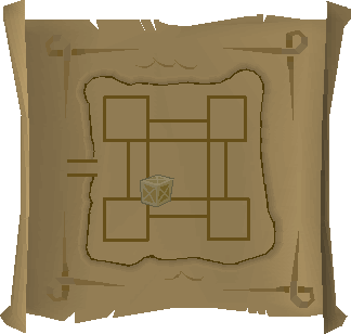
In level 19 Wilderness, at the Dark Warriors' Fortress, search the pile of crates in the south-west corner of the central courtyard. Warning: This area is a hotspot for player killers. | File:Treasure trails solution map 78.png |
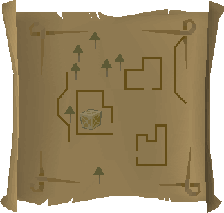 |
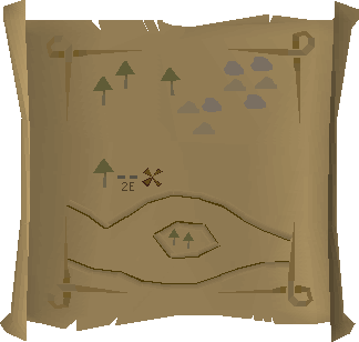
North east of the Observatory, north of Castle Wars, search a crate in the westernmost building of the goblin overrun houses. This house holds the entrance stairs to the dungeon below. | File:Treasure trails solution map 32.png |
|
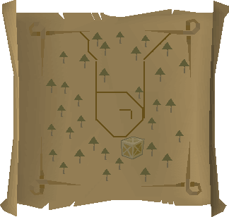
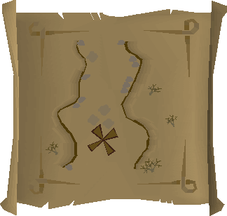
Inside McGrubor's Wood, west of Seer's Village. Fairy ring code A•L•S. If approaching from outside, squeeze through the broken fence by the northern half of the hut in the center and search the crate south of the house. Warning: Guard Dogs |
Maps with an X and buildings
| Map | Location | Image |
|---|---|---|
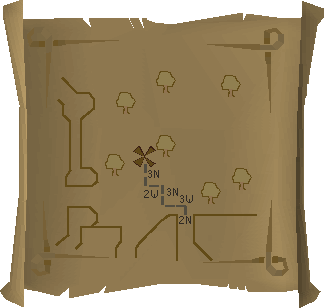
| Directly behind the Wizards' Tower, there's a fern you can use as a reference, the dig spot is one tile directly north-west of the fern. | ||
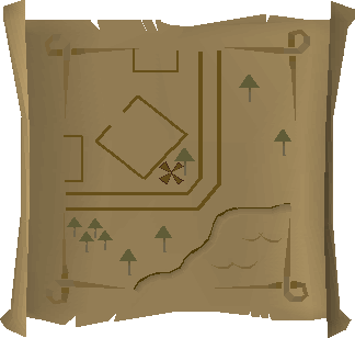
| File:Coal Truck House Clue.png | 2 grid squares north of the west door of Galahad's house west of McGrubor's Wood. | File:Solution7 Map.png |
|
Just west of the chemist's house in Rimmington. South of Falador, west of Port Sarim. | File:Map clue solution Chemist house map.png |
|
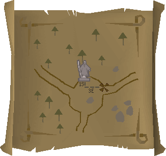
On Miscellania, one of the Fremennik Isles, just east of the castle. Fairy ring code CIP. | File:Treasure trails solution map 70.png |
 |
South of Yanille bank. Behind the house with an anvil. | File:Treasure trails solution map 36.png |
|
Just south of East Ardougne, north of the Tower of Life, near the Necromancer's tower. Dig 2 spaces north of the smaller crate that Bonafido is leaning on. Fairy ring code (D-J-P) is very close. Look for the construction worker usually counting in the mid thousands. | File:Treasure trails solution map 47.png |
Maps with an X but no buildings
| Map | Location | Image |
|---|---|---|
 |
Just north of Falador in the standing stone circle | File:Map clue location Falador stones.png |
 |
The river adjacent to the Champions' Guild, near Varrock, south of the nearby mine. | File:Champions Guild Clue Solution.png |
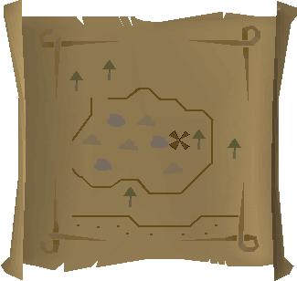
| Just north of Al-Kharid, in the center of the mine. | ||
 |
Just north of Falador, at the crossroads where there is a statue. | File:Cross roads.png |
 |
South-eastern Varrock Mine | |
|
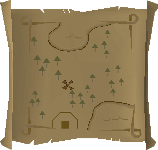
North of Seer's Village, along the path towards Rellekka. | |
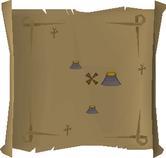 |
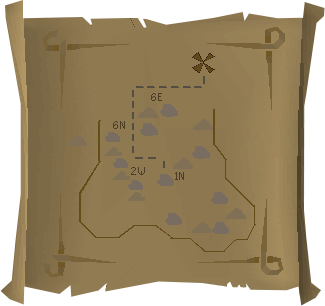
Level 50 Wilderness, near Wilderness Agility Course; south-west of Deep Wilderness Dungeon entrance and west of the Mage Arena; dig between the three small volcanoes.Warning: This area is a known hotspot for player killers. | File:Treasure trails solution map 29.png |
|
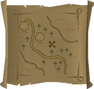
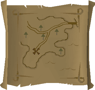
Road between Rellekka and the Lighthouse | File:Treasure trails solution map 89.png |
|
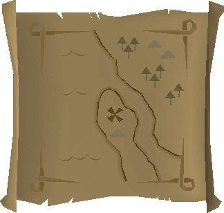
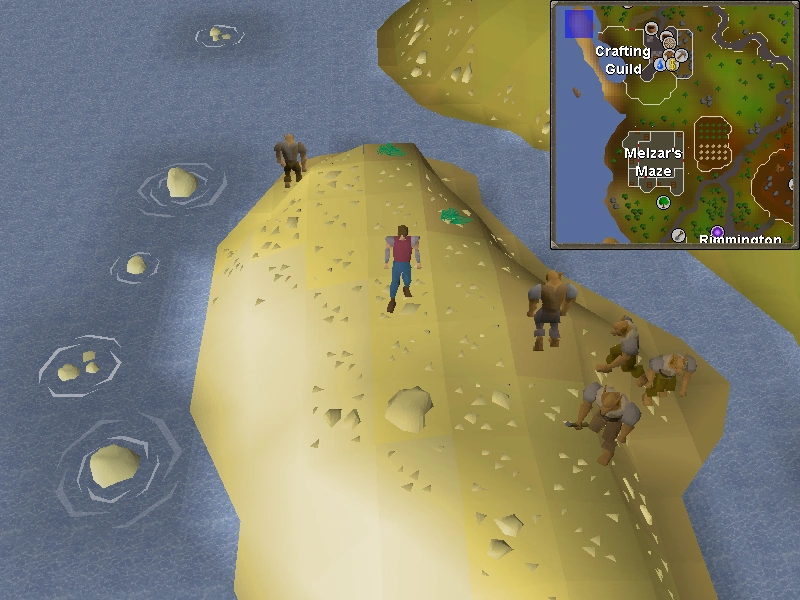
Near the Crafting Guild on the peninsula.
 |

Maps with an X and a fishing spot
| Map | Location | Image |
|---|---|---|
 |
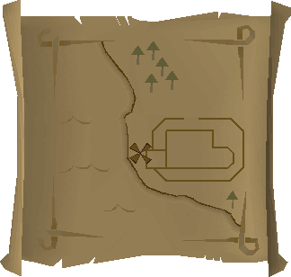
South of Draynor Village bank, by the fishing spot. | File:Solution19 Map.png |
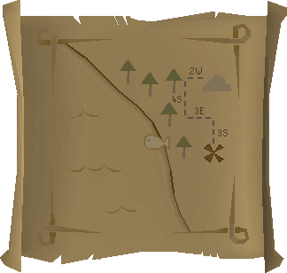
| North of the Abandoned Mine, by the path to Mort'ton. | File:Solution17 Map.png |